


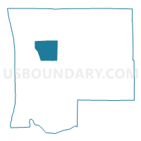
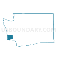
Bay Center Voting District, Pacific County, Washington
About
Outline

Summary
| Unique Area Identifier | 687859 |
| Name | Bay Center Voting District |
| County | Pacific County |
| State | Washington |
| Area (square miles) | 36.64 |
| Land Area (square miles) | 21.99 |
| Water Area (square miles) | 14.64 |
| % of Land Area | 60.03 |
| % of Water Area | 39.97 |
| Latitude of the Internal Point | 46.60719110 |
| Longtitude of the Internal Point | -123.93413460 |
Maps

Graphs
Select a template below for downloading or customizing gragh for Bay Center Voting District, Pacific County, Washington


Neighbors
Neighoring Voting District (by Name) Neighboring Voting District on the Map
- Nemah Voting District, Pacific County, WA
- Oysterville Voting District, Pacific County, WA
- South Bend 1 Rural Voting District, Pacific County, WA
- South Bend 2 Rural Voting District, Pacific County, WA
Top 10 Neighboring County Subdivision (by Population) Neighboring County Subdivision on the Map
- Long Beach-North Beach Peninsula CCD, Pacific County, WA (9,107)
- Raymond CCD, Pacific County, WA (7,892)